Our adventure down the Snowy River in Australia is still on! In my last post about it, I mentioned that I wanted to talk about the planning process, to be honest about the logistics and all the work that goes into the trip before we head off in March. So, here goes. (This post got a bit out of hand with the videos!)
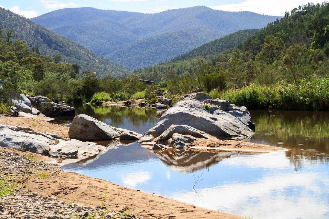
Snowy River (cc) John. Ahh, looks relaxing.
Back in July, several people said they were interested in helping out with food drops and maybe joining us on the river. Some mentioned camping with their families or joining us for a rest day in town, others liked the idea of walking with us through the high country, some even suggested bringing their ponies or bikes and heading off ahead down the road to meet us at the next campsite. Understandably, as we start following up on these expressions of interest, some folks won’t actually be able to come - the dates won’t suit, they’ll have made other plans for their holidays, or it’s simply too far to drive.
I’ve pared our list of things we need people to help us with down to nine essential transport and food related tasks, a few “it’ll make everything so much easier” things and a couple of nice-to-haves. Most of these fall into five or six clusters (e.g. three tasks in one cluster might be: bringing a food drop to Buchan, picking us up from the river and driving us into town, maybe checking out the caves with us, then driving us back to the river a day or two later). Hopefully we will get most of this organised over the next month or so.
I’ve pared our list of things we need people to help us with down to nine essential transport and food related tasks, a few “it’ll make everything so much easier” things and a couple of nice-to-haves. Most of these fall into five or six clusters (e.g. three tasks in one cluster might be: bringing a food drop to Buchan, picking us up from the river and driving us into town, maybe checking out the caves with us, then driving us back to the river a day or two later). Hopefully we will get most of this organised over the next month or so.
Timelapse footage of the Snowy River near Charlottes Pass, Summer 2015.
Food: Speaking of food, Kate has been concocting tasty morsels for us - a dehydrated dhal seems to have worked well (and lasted OK for six weeks before rehydrating!) and we’ve been chatting about salty tomato fruit leathers and the pros and cons of Deb (instant mashed potato) and pasta. Semolina is going to act as a base for a couple of meals (sweet and savoury). Maybe I will have to overcome my intense dislike of cous cous, as it is such a useful travel food.
Gear: We are a bit behind with getting our gear together, mainly because we spent all our money on fun things like canoeing and Champing. We visited the Alpkit warehouse/showroom a couple of months back and it was fantastic! We’d been thinking of getting an Ordos 2 tent for this adventure, but the Ordos 3 is so much more spacious and almost free standing, with only a slightly bigger footprint and an extra 300g of weight. Decisions, decisions! Now we just have to save more money . . . We did get a Brukit (and then, several weeks later, some gas) which works a dream for cups of tea and instant noodles; soon we’ll try it with something more substantial. Also, we have bought travel insurance, woohoo! (I know, it’s not exciting, but it’s one of those things you just have to do.) As we often have before, we used World Nomads.
Adventure time: My dad has sourced us a couple of tractor tyre inner tubes for the downstream sections. Who doesn’t love the idea of inner tubing down a river?! Adventures don’t have to be Serious Business At All Times. I’ve also done some more in-depth route planning, which means I have a list of maps to buy, and also the following conundrum to work out . . .
Tulloch Ard? More like Tulloch Hard!
So, north of McKillops Bridge, the Snowy looks a bit like this.
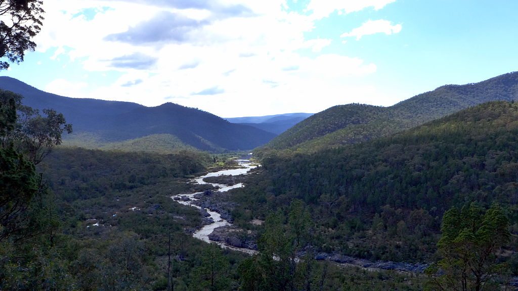
The Snowy River as seen from the Barry Way, north of the Victoria/New South Wales border.
The river, which hasn’t really had full flow down it since the dam at Jindabyne was completed in 1967, cuts a smaller channel down the wide, flat river bed. There might be crevasses between the rocks, there might be a lot of tough underbrush growing in the old river bed, we might need to wade across the river sometimes to find a path - but I think that we will be able to walk or scramble our way along it. We’ll at least give it a bloody good try!
But south of McKillops Bridge, there are sections where the river looks more like this. The river enters gorge country, where the riverbed is much narrower. Very steep hills or cliffs slice right down to the water. There are a couple of points where the bottom of the valley is impassable on foot. I couldn’t find any Creative Commons photos of the gorge from the river, but you can see images here and here. Likewise, I can’t see any Creative Commons images from the Tulloch Ard Gorge lookout, so instead here's a picture of Little River Gorge, just before Little River enters the Snowy, to give you an idea of nearby terrain.
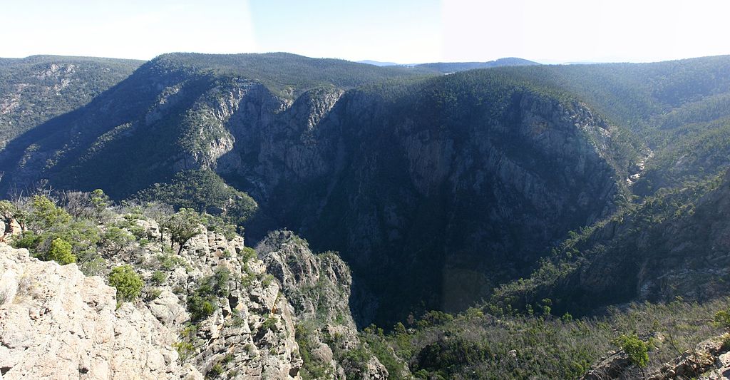
Little River Gorge (cc) Wikimedia. The Snowy gorges aren't quite so deep and sheer!
Most people I'd spoken to were saying we’d have to paddle some of the gorge sections downstream of McKillops Bridge. These people happened to be kayakers rather than walkers, so I wasn’t entirely convinced - but in the absence of other knowledge, I looked into paddling options. The easiest put-in and put-out points for a kayak or sports raft are at McKillops Bridge upstream and the confluence with the Buchan River downstream, at Balley Hooley campsite. This is probably the most popular section of the Snowy to paddle, so there is plenty of info about it. I started listing ideas.
1. Paddle - bring our own craft and gear. You can read the blog of someone who did a trip like this from Kosciuszko to the Coast. They missed out the upper section of the Snowy, instead taking the overland/shorter route south from Mt Kosciuszko/Targangal and meeting the Snowy River at Pinch River, above McKillops Bridge. As you can see if you read that blog post, there are only a few short sections where walking/scrambling probably isn’t possible, but because the river is deep, narrow and full of rapids, I don’t like the idea of trying to swim or wade them.
The benefit of having our own packraft/s is that we wouldn’t have to rely on many other people - in fact, we could use the boats all the way down the river, whenever we wanted. Also, they’re apparently pretty comfortable to sleep on! The downside to this is that it’s expensive to buy decent packrafts, paddles, floatation vests and possibly helmets - and it’s pretty heavy to lug around all that stuff if you’re not using it. Also, we’re more interested in walking and scrambling than paddling; having packrafts with us would really change the timbre of our adventure. Also, if you’re paddling whitewater without a qualified guide, insurance companies start charging massive premiums - or simply won’t cover you. (You might see why when you watch the following video! This is not usually what the river is like - this was filmed during one of the big environmental water releases.)
The benefit of having our own packraft/s is that we wouldn’t have to rely on many other people - in fact, we could use the boats all the way down the river, whenever we wanted. Also, they’re apparently pretty comfortable to sleep on! The downside to this is that it’s expensive to buy decent packrafts, paddles, floatation vests and possibly helmets - and it’s pretty heavy to lug around all that stuff if you’re not using it. Also, we’re more interested in walking and scrambling than paddling; having packrafts with us would really change the timbre of our adventure. Also, if you’re paddling whitewater without a qualified guide, insurance companies start charging massive premiums - or simply won’t cover you. (You might see why when you watch the following video! This is not usually what the river is like - this was filmed during one of the big environmental water releases.)
2. Paddling tour - get a group together and go on a guided tour. A few companies do guided tours down this part of the Snowy and this would be pretty lush, as they organise transport for all the rafts/kayaks and gear and some of them also cook all your food for you! You get the benefit of an experienced guide 24/7 which makes the whole thing a lot safer and, if your guide’s any good, you get to hear a lot more about the areas you’re passing through. But where a guided tour would make things easy in theory, in practice there’s a major hurdle: you need a minimum of 4-6 people for most tours, and it costs about $1000 per person for the four day trip. While we are OK to fork out the money as part of our adventure, we had a grand total of no people express real interest in joining us for this. Another downside to the guided tour thing is that, once again, it would change the feel of our journey.
Kayaking from McKillops Bridge to Buchan River with a tour group.
3. Paddle hire - hire a sports raft and paddle by ourselves. We could hire the craft, paddles, safety gear and waterproof barrels/bags for the four days between McKillops Bridge and Buchan, arrange transport for the gear to/from the river, and off we go. It’s the least expensive option and also fairly in keeping with our DIY adventuring style. We’ve recently done more paddling and discovered that we like shooting rapids, though when I looked for videos and images of the rapids on the Snowy River, they usually showed the biggest ones - the whitest water, the largest rocks, the narrowest chutes. In the gorge, rapids range up to Class IV which, if you read Wikipedia, is somewhat beyond our level of paddling prowess: “Risk of injury to swimmers is moderate to high, and water conditions may make self-rescue difficult. Group assistance for rescue is often essential but requires practiced skills.” Eek! However, further investigation (checking online maps, poring over photos and videos, reading blog posts and talking to our man on the river) revealed that there are good maps with the major rapids marked on them and that we could portage around them when needed.
Unfortunately, while I'd convinced myself and Dan that this was going to be our best option, convincing a company to hire the equipment to us, especially when the water levels might be quite low after summer, was another matter. I can’t say I blame them for their reluctance (I know we’re safety conscious and won’t be stupid; they don’t). After a couple of failed email threads and awkward early morning international phone conversations, I started to get pretty anxious and considered ditching the section entirely. There was only one other option . . .
Unfortunately, while I'd convinced myself and Dan that this was going to be our best option, convincing a company to hire the equipment to us, especially when the water levels might be quite low after summer, was another matter. I can’t say I blame them for their reluctance (I know we’re safety conscious and won’t be stupid; they don’t). After a couple of failed email threads and awkward early morning international phone conversations, I started to get pretty anxious and considered ditching the section entirely. There was only one other option . . .
4. Walking - scrambling up and over the hills when necessary. Back to square one. Walking. As it happened, my parents were catching up with someone who used to live near Orbost and who is a keen bushwalker. He and a few friends had walked the Snowy in sections downstream from Jindabyne in the late 1980s. I got in touch with him by email to get some hints and tips. “I went on foot the whole way, including the gorge stretch,” he told me. “It was a bit of a challenge but really not all that difficult to go up along some of the ridges beside the river. There are lots of animal tracks to follow - so it is possible.”
After tying myself in knots trying to organise the paddling malarky, it turned out that perhaps we could get along most of the section on foot after all. And where it’s not feasible to stay right beside the river, we could engage in a bit of cross country bushbashing. I went back to my timeline and maps, made some measurements, checked for tracks and access roads and eventually decided that we could probably still get to the Buchan River on the day we originally intended. Yes, there would be a few long, hard days of walking, but by that point in the trip we should be fitter than we have been for years (if not ever!), so hopefully it wouldn’t be too bad. We might also choose to walk the last long day along tracks and roads instead of along the Snowy itself, but I’m not going to stress about it - after all, it’s not meant to be a scientific survey of every metre of the river!
After tying myself in knots trying to organise the paddling malarky, it turned out that perhaps we could get along most of the section on foot after all. And where it’s not feasible to stay right beside the river, we could engage in a bit of cross country bushbashing. I went back to my timeline and maps, made some measurements, checked for tracks and access roads and eventually decided that we could probably still get to the Buchan River on the day we originally intended. Yes, there would be a few long, hard days of walking, but by that point in the trip we should be fitter than we have been for years (if not ever!), so hopefully it wouldn’t be too bad. We might also choose to walk the last long day along tracks and roads instead of along the Snowy itself, but I’m not going to stress about it - after all, it’s not meant to be a scientific survey of every metre of the river!
So that’s the state of our planning at the moment. I expect I'll update you again in another couple of months - hopefully when we've made some more decisions, bought some more equipment and organised some more people to help out.
 RSS Feed
